The Tourist information office of Hermalle-sous-Huy "La Rawète" informs you about geography, landscape, communications and timetables for Hermalle-sous-Huy, place of tourism and culture between Liège and Huy, province of Liège, Wallonia, Belgium 

Geographical Location


Location

Geology/Landscape

Communications

Timetables
70' Bruxelles / Brussel
35' Namur / Namen
25' Liège / Luik
10' Huy
04' Engis & Amay


Location :

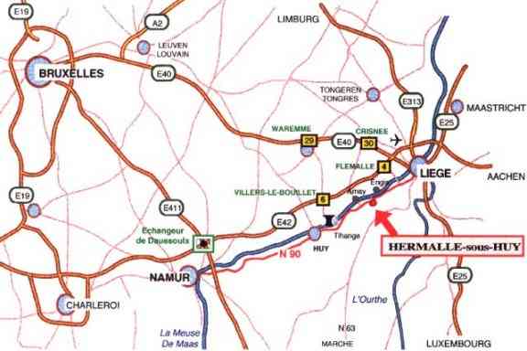
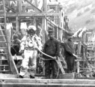
Hermalle-sous-Huy is in Wallonia (left south of Belgium, one of the countries of western Europe).
The village is essentially situated on the right bank of Meuse, to 11 km downstream from Huy, 23 upstream from Liège, to 5 km of Tihange, 12 of Nandrin, 4 of Engis and 4 of Amay.
Its territory stretches along the river, from West to East, from Ombret and Clermont-sous-Huy to Ehein.
The village is crossed, in all its length, by the street Freddy Terwagne (portion of the N644), where are located most trades and, in the Farm castrale, the Tourist information office.
Perpendicularly to this axis, the Rue du Pont starts from the old local house to head for the river (from where the old name "Rue de Meuse"). On the left, while descending the street, are the nursery and primary school, and an educational natural reserve; opposite, the Center of creativeness, the local Library and the Cultural Centre Camille Jamagne (asbl Centre culturel de l'entité engissoise).

At the end of this street, on the bank of Meuse, an industrial activity park welcomes small and middle industries benefitting from various ways of transports (road, railroad n° 285 permitting a speed of 40 km/h on 1 way of 7,9 km, and fluvial harbor).


Geology, Landscape :

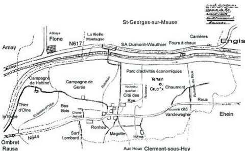
Hermalle-sous-Huy is in the major bed of Meuse, bed digged to the Tertiary between the hard layers of the limestones and carboniferous dolomites (360 to 300 millions years) on the right bank, and the more tender layers of the shales Silurian (495 to 400 millions years) and sandstones of the devonian (400 to 360 millions years).
Meuse currently visible is recent: tertiary time - 40 millions years at more; it constituted itself by recession of the sources, from old river affluents (Hoyoux, Mehaigne, Geer, Ourthe, Meuse of Visé) that were consequent to the marine shore oscillating at the time around a line between Brussels, Tongeren and Maastricht.
The coast that one recovers behind the village, and that goes up until the shelf of the Condroz, first permits to see, after having left the alluvial plain (and its recent alluviums of silts, sands and rolled stones), very old schist, greatly eroded, in gentle slope (until the fountain Saint-Martin, to the bottom of Oxhe, in the Thier d'Olne). It becomes steeper when it approaches the sandstone rocks, harder and therefore less eroded, and then the first rocks of the Condroz.
Vegetation will have therefore an acidic type in the majority, with beechwood, bracken and blueberries.

The construction of the fast way at the edge of Meuse in 1988 (that canalized the important road circulation), the steeply sided setting of the valley in direction of Ehein, the gentle slopes of meadows and woods toward Clermont-sous-Huy and Ombret, preserve fortunately a landscape where the broad-leaved trees border the verdant pastures.


N644, Ombret-Hermalle 2003, photo BMG


Next to : cows of Limousin at the pasture, photo BMG


Communications :

j
The nearest airport is Bierset (Liège), ± 20 km from Hermalle-sous-Huy.

u
The station of Hermalle-sous-Huy (situated on the left strand of Meuse, at the Mailleue, since ± 1854) having been closed in 1984 to the "travelers" traffic, the railway stations nearest the village are those of Engis and Amay.
The station assures always the loadings and discharges of goods.

v

Hermalle-sous-Huy is served by the
service 9 of the Société de Transport en commun TEC (stop "Place d'Hermalle", chaussée Freddy Terwagne).

In the center of the village cross the Big hike Trails/Rambler's routes 576 & 579.

b ” Service 1 of the RAVeL, walloon of "slow" road network.

Ž
The village is directly accessible by the national roads 644 and 90 (fast way to 4 strips of circulation, exits "Hermalle-sous-Huy" from Huy, and "Pont de Hermalle" from Liège).
The "
Pont de Hermalle" (Bridge of Hermalle) allows the access the national road 617 (halfway between Amay and Engis).
 
- The first road that passed through Hermalle-sous-Huy was the one of Gerée (sometimes named "old Roman way") that joined the hamlet to the ford of Amay, on the Roman road Tongres-Arlon, to the bottom of the hill said Thiers d'Olne. It is by this ancient way, that goes against the castle, the "Ferme castrale" and the church Saint-Martin, that the American liberation army (coming from Amay) entered to the village September 7, 1944.
- At the 18th century, Hermalle-sous-Huy possessed a postal service's relay on the Liège-Huy road (present N644) and Napoléon would have lodged there in 1810.
- Until 1908, people cross the Meuse by ferry. The local authorities decided to build a bridge made with reinforced concrete. Second of this type on Meuse, it was builded in 5 months with help of divers, and inaugurated with ceremony.
.........................coll.BMG
Destroyed in 1914 (1st world War), it was rebuilt some ' 23. World War II only let a pillar of it in 1940, and it was necessary to rebuild again this work - that was the last, in Belgium, to be a local property.
- The construction of the N90, "fast way" destined to make easier the evacuation of the population in case of incident in the nuclear power station of Tihange is considered in the plan of mobility of the zone of Meuse-Hesbaye police as axis of transit Heavy Weights (+ of 7,5 t) ; it isolated a district of the village: you can only reach the hamlet of Chaumont by the north extremity of the Rue du Pont.

è

The village has three parking spaces: Place des Combattants (square of the St.-Martin's church, next to the Ferme castrale), place de Hermalle and Rue du Pont (opposite the local school).


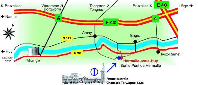
Road : N90, exit "Hermalle-sous-Huy - Pont de Hermalle"
Bus : Service TEC n° 9 Liège-Huy, stop "place de Hermalle" (300 m.)
Big hike Trails/Rambler's routes 576 & 579
The "Ferme castrale" is very close the church.
Road access : N90, exit "Hermalle-sous-Huy" or "Pont de Hermalle"
Bus access : Service TEC n° 9, stop "place de Hermalle" (300 m. from the Ferme castrale)
Rambler's route/Big hike Trails : where the long-distance footpaths 576 & 579 cross


Tourist information Office : Ferme Castrale

chaussée Freddy Terwagne 132a

Saturday 2-7 pm,
Sunday 11 am-7 pm,
weekday : +32-(0)85 31 42 86 &
info@hermalle-sous-huy.be

Old Centre :

Buildings from the
17th and 18th century

1
2

3
4
5
6
7


8
9
Castle
Ferme castrale - TIO
Musea & Gourmet Library
Church Saint-Martin
Cense Cassal
"Farm Dacosse"
Old house of the vicar
Native house of Jean-
Gilles Jacob (to-day presbytery)
Old Post relay
"House Sacré"


Buildings from the
19th and 20th century

10

11
12

13
14
15
16
Old community centre (Maison de la Laïcité)
Old schools (CEC)
Cultural Centre & Public Library
Hall L'Amicale
Area Magotte
Hall Francis Grandfils
Chemist's/pharmacy


Timetables

Tourist information office,
Ferme castrale,
All year round
Saturdays 2-7
pm & Sundays 11 am-7 pm
Gourmet Museum : Guided visits

- Saturdays at 2, 4 & 6 pm,
- Sundays at 11 am, 2, 4 & 6 pm,
- Weekdays : on request for groups
é Special access on request
è Cars and coaches
Inn of the Museum : - Saturdays 2-7 pm & Sundays 11 am-7 pm
- Weekdays : on request for groups
Public Library :


Gourmet Library :
Monday 11-12am & 1-4.30pm, Tuesday 1-4.30pm, Wednesday 4.30-7pm, Thursday 9-12am & 3.30-7pm h, Saturday 9-12am - closed Friday & Sunday
Only on request
Cultural centre : Office : from Tuesday to Friday 8.30am-16.30pm
Shops : click here


 N.p.o. Tourist Information Office of Hermalle-sous-Huy (La Rawète)
in the farm "Ferme Castrale" of Hermalle-sous-Huy

province of Liège, between Liège and Huy, Wallonia, Belgium